
 Phisiography of Pakistan: The Physiography frame work of Pakistanhas been built by two major geometric processses that have produced two distinct phsiographic entities.
1. The Western Highlands produced by the mountain building movement extended from the Makram coast in the south to the Pamir Plateau in the extreme north.2. the indus Plains resulting from the deposition of sediments from the Indus river and its tributaries.The western highlands cover most of the Baluchistan, NWFP, Northern Areas (Gilgit Agency) and parts of the Panjab.The western Highlands cover most of the balochistan, NWFP, Northern areas(Gilgit Agency) and parts of the Panjab.Mountainous north covers The Himalayas, The karakoram, The Hindu Kush.
 Balochistan Plateau is located west of the Sulaiman -Kirthar Mountais. The Potwar Plateau and the salt Range region are located to the south of the Mountainous north and lie between the Indus river on the east. Its northern boundary is formed by the Kala Chitta Ranges and the Margalla Hills and the sothern boundary by the salt ranges. the Indus Plane have been formed by the alluvium laid down from the river Indus and its tributaries.The Indus receives a number of tributaries from the west : Kabul River, Kurram, Tochi,and the Gomal river. The red side tributaries areJhelum, Ravi, and Sutlej.

 Balochistan Plateau is located west of the Sulaiman -Kirthar Mountais. The Potwar Plateau and the salt Range region are located to the south of the Mountainous north and lie between the Indus river on the east. Its northern boundary is formed by the Kala Chitta Ranges and the Margalla Hills and the sothern boundary by the salt ranges. the Indus Plane have been formed by the alluvium laid down from the river Indus and its tributaries.The Indus receives a number of tributaries from the west : Kabul River, Kurram, Tochi,and the Gomal river. The red side tributaries areJhelum, Ravi, and Sutlej.
 Rain fall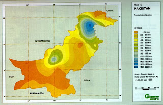 The Deltaic plains have in fact been built by the Indus as a large delta at its mouth.
 Soil classification
 The Deltaic plains have in fact been built by the Indus as a large delta at its mouth.
 Soil classification