Tuesday, March 31, 2009

Mozambique, after independence

The last 30 years of Mozambique's history have political developments elsewhere in the 20th. century. Following the April1974 coup, initiated by a leftist group, in Lisbon, Portuguese colonisation collapsed. in Mozambique, the military decision to withdraw occurred within the context of a decade of armed anti-colonial struggle, initially led by American educated Eduardo Mondlane, who was assassinated in 1969.When independence was proclaimed in 1975, the leadersof FRELIMO"S military campaign rapidly established a one-party state allied to the Soviet bloc and outlawedrival political activity. FRELIMO eliminatedpolitical pluralism, religious educational institution, and the role of traditional authorities.
The new Govt. under president Samora Machel, gave shelter and support to south African
( African National Congress) and Zimbabwean(Zimbabwean African National Unity) liberation movements while the Govt. of first Rhodesia and later South Africa( at that time still operating the Apartheid laws) fostered and financed an armed rebel movement in cintral Mozambique called the Mozambican national Resistance (RENAMO). Hence, Civil war, sabotage from the neighbouring states , and economic collapse charterised the first decade of Mozambique independence. Also marking this period wee the mass exodus of Portuguese nationals , weak infrastructure , nationalisation, and economic management. During the civil war urban people were cut off from the effective control of the capital. An estimated 1 million Mozambicans were perished during the civil war, 1.7 million took shelter in neighbouring states, andseveral million more were internally displaced.
In the third party congress in 1983 of FRELIMO the President Samora Machel agreed that Govt. failed to implement the requisites of socialism and advocated for the economic liberisation. He died along with several advisers, in a suspecious plane crash.
His successor, Joaquim Chissano, continued the reforms and peace talks with RENAMO. a new constitution was enacted in 1990provided for a multiparty political system.

Monday, March 30, 2009

Mozambique, War of independence

After WWII, while many European nations were granting independence to their colonies, Portugal clung to the concept that Mozambiqueand other portuguese possessiong were overseas provinces of the mother country, and emmigration to the colonies soared. Mozambique's Portugal population at the time of independencewas about 2,50,000. the drive for Mozambique's independence developed apace, and in 1962 several anti-colonial political groupsformed the Front for the liberation of Mozambique( in Portuguese FRELIMO) with the Soviet and China's help.
The Mozambican War of Independence was an armed conflictbetween the guerrilla forces of the FRELIMO and Portuguese forces.The FRELIMO initiated a guerrilla campaign aginst Portuguese rule in Sept. 1964.This conflict along the two other Portuguese colony Angola nd Guinea- Bissau became part of the Portuguese colonial war(1961-1974). From a military standpoint, Portuguese regular armymaintained contrl of the populationcentres while the guerrilla forces sought to undermine their influence in rural and tribal areas in the north and the west.
After 10 years of sporadic warfare and Portugal's return to democracy through a leftist military coup in Lisbon which which replaced Portugal's Estado Novo regimeand gave independence to FRELOMO. Within a year , about 2,50,000 portuguese in Mozambique left for Portugal.

Sunday, March 29, 2009

Mozambique, History (continued)


While most of the population of Mozambique is of Afrcan origin, it has a number of oeople of portuguese, Arabs, Indians, and east asian descent who came here before and after the colonial era.People from Goa and Macao came to Mozambique from these erstwhile portuguese possissions in Asia. During 16th. century small group of Portuguese traders and prospectors penetrated the interior regions seeking gold where they set up garrisons and and trading posts at rena and Tete on the Zambezi riverand tried to control exclusive control over the gold trade. The Portuguese attempted to legitimate and consolidate their trade and settlement positions through the creation of Prazos (land grants)tied to portuguese settlement and administration.

Although portuguese influence gradually expande, its power was limited and exercesedthrough individual settlers and offcials who were granted extensive autonomy.

As communist and anti-colonial ideologies spread out across Africa, many political movements were established in support of Mozambican independence.


Mozambique war of independence
(clock wise from left) a portuguese supply convoytraverse the country side, a foot petrol of portuguese soldiers,portuguese troops embark, portuguese armoured.
By the early 20th. century the Portuguese had shifted the administration of much of the country to large private companies , contolled and financed by the British which established railroads , supplied cheap sometimes forced African labor to the mines and plantations from near by British colony, as South Africa.

Mozambique, history


Mozamique's first inhabitants wereSan hunters and gatterers, ancestors of the Khoisani peoples. Between first and fourth century AD waves of Bantu speaking peoples migrated from the north through the Zamberi river valley and then gradually into the plateau and coasal areas in the first millennium.The Bantu were farmers and ironworkers.
Thereafter Arab and Swahili traders settled the region. It was explored by Vasco da Gama in 1498 and Mozambique was first colonized by portugalin 1505. By 1510 the Portuguese conrolled all the former Arab Sulltanates on the east Africancoast. Portuguese colonial rule was repressive.

The island of Mozambique is a small coral island at the mouth of Mossuril Bay on the Nacala coast of northern Mozambique, first explored by Europeans in the late 1400s. The portuguese trading postsand forts became regular ports of call on the new route to the east .Later, traders and prospectors penetrated the interior regions seeking gold and slaves.Portuguese influence gradually expanded through the individual settlers having extesive autonomy. As a result , investment logged while Lisbon devoteditself to the more lucrative trade with India and the far east and to the colonisation of Brazil.

Saturday, March 28, 2009

Mozambique, Intrduction

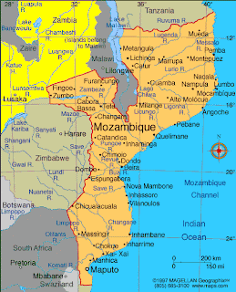
Officially known as republic of Mozambique, is situated in the southeast of Africa with Indian Ocean in the east of it.
Mazambique in Africa
Physical map of Mozambic
Political map of Mozamique
Mozambique was named after Muca Alebique, a sultan. It is member of the community of Portuguese language countries. Tanzania, Malawi and Zambia are to the north, Indian ocean is to the east and south and tanzania, Malawi, Zambia, Zimbabwe, South Africa and Swaziland are to the west.
It was explored by Vasco da Gama in 1498 and colonized by Portugal in 1505. By 1510, the Portuguese had controlled all the former Arab sultanson the east African Coast. From about 1500, portuguese trading posts and forts became regular ports of call on the new route to the east.
Its rank in the list of per capita income by ATLAS method, 2003 est.,is 195th. and average per capita income is 210 $. there are 10 countries whose gdp per capita ,2003 est.,atlas method are less than that of Mozambique.

Friday, March 27, 2009

Niger, Pictures from internet


The Erg of Bilma in the east of Niger
The Kaouar escarpment, forming an oasis in the Tenere desert.
A farmer collecting millet in Koremairwa village in the Dosso department
Nigerian soldiers in
Niamey, Niger's capital and economic
The fertile south of niger near the niger River

Thursday, March 26, 2009

Niger, Economics and politics

The National Assembly passed in June, 2002 a series of decentralisation bills. As a first step , administrative powers will be established as decentralised entities. A new electoral code was adopted to reflect the decentralisation context.
Economy
Niger is one of the poorest countries in the world,ranking last on the United Nations Human Development Index,Niger's economy is largely based on subsistence crops,livestock and some of the world largest uranium deposits.
Niger's agricultural and livestock sectors are the main stay of all but 20% of the population. 14% of Niger's gdp is generated by livestock prouction - camels, goats, sheep,and cattle- said to support 29% of the population. 15% of the niger's land is arablewhich is along its southern border with Nigeria.

Hduman development index gives a more complete picture than income.

Human Property in Niger: focussing on most deprived in multiple dimensions of poverty.

Niger's human development index 2005

HDI value ....Life expectancy at birth....Adult illeteracy....gdp per capita

174-.374...........146/55.1..................136/28.7...............178/781

Tuesday, March 24, 2009

Niger, after independence

After Independence Nigerians lived under five constitutions and 3 periods of military rule.
For the first 14 years, niger was run by a single party civilian regime under the presidency of Hamami Diori.


President Hamami Diori and visiting german presient Dr. Heinrich Lubke greet crowds on a state visit to Niamey ,1960. Diori's single party rule was characterised by goo relations with the west an a preoccupationwith foreign affairs.
In 1974, a combination of devastating drought and accusationsof rampant corruption resulted in a coup d'tat that overthrew the Diori regime. Col. Seyni Kountche and a small military group ruled the country until Kountch's death in 1987. He was succeeded by his Chief of Staff, Col. Ali Saibou,who some bold steps. He released all political prisoners, liberized some Niger's laws and policies and promulgamated a new constitution. But that was the Second Republic with the constitution of single party rule. It also failed due to the demand by students and youths union. As a result another new constitution came up after discussion and conferences. A transition Government under the leadership of Prof. Andre Saliou, was installed as caretaker Govt. in April 1993, as Third Republic.
At this time freedom of the press flourished with the appearence of several new independent news papers.
The jan. 1995 parliament election ended in rivalries between two parties and Col.Ibrahim Bare over throw the third republic in Jan. 1996 installing another (last) military rule.An attempt was made to draft a new constitution and his party won 57% of seats in Parliament to form the fifth Republic in April 1999.


Mamadou Tandja, President of the Republic of Niger.

Sunday, March 22, 2009

Niger, Pre-independence Period


Songhai Epmire at its top position, c 1500


It was as back as 600,000 BC when people began to stay in the areas of north of Niger because at that time the land was fertile for cultivation and abundant wild life , domesticated animals, chariots used to live.


At About 1400s Songhai Empire expanded into what was modern Niger. Different types of kingdoms existed at different times before it was explored by the western countries in the 19th. century. The first European explorers-notably Mungo Park (British) and Heirich Barth (German) -explored the area in search of the source of the river Niger.But ultimately French occupied the territories for their colony and administered it from 1922. Like other French West African Colony they posted a governor general in Niger as they had done in Dakar, Senegal etc.


The colonies governed by the French had got its own method of doing things unlike that of the others. In addition to conferring French citizenship to the inhabitants of the territories, the 1946 French constitution provided for ecentralisation of power and limited participation in political life for local advisory assemblies.


A further revision in the organisation of overseasterritories occurred with the passage of the Overseas Reform Act (Loi Cadre)of July 23,1956,followed by reorganisationmeasures enacted by the French Parliamentearly in 1957. In addition to removing voting enequalities, these laws providedfor creation of Governmental organs assuring individual territories a large measure of of self-government.


After the establishment of the Fifth French Republic on Dec.4, 1958, Niger became an autonomous state within the French Community. \Following full independence on Aug. 3, 1960, however,membership was allowed to lapse.
Ruins of the trade oasis of Djado in north-east niger

Saturday, March 21, 2009

Niger, map


Niger is situated in the western part of Africa

Niger is slightly greater in area than that of the South Africa but its population is slightly less than that of Delhi whose area is almost thousand times less than that of the Niger. Officially it is known as the Republic of Niger. It is a landlocked country, after the name of the Niger River which flows south-west end of the country and is the only river with its trajectories. its GDP (PPP) per capita, est.2007, is $312i.e. less than 1$ per day. To the south there are Nigeria and Benin, to the west Burkina Faso and Mali,to the north Algeria and Libyaand to the east is chad. It is the largest nation in the west of Africa. Niger is one of the poorest and least developed country in the Worldfor 80% of its territory is covered by desert and the rest is threatened by drought anfd desertification. Niger remains handicapped by its landlocked position, poor education,poor infrustructure, poor health care,and environmental degradation.

After independence Nigerians lived under 5 constitutions, and 3 periods of military rule.

Friday, March 20, 2009

Eritrea, colonialism (continued)

Tekeste studied the theory of colonialismin of Italy in Eritrea. He pointed out that the Marx-Hobson-Lenin theory of imperialism depicted that the task of colonialism is to create precondition for industrial capitalism because colonialism is the starting point of capitalism. Tekeste explains Italian imperialism in four stages;
i)itreflects the peculiarities of Italian colonial policies pattern in Africa in contrast to the general policy of British and French pattern in Africa.
ii) Italian policy shifted shifted from an early emphasis on either colonialism (182-1896) through a period of uncertainty (1897-1906)
iii) This was resolved by Governer Martini who laid the foundations for an era of rational
imperialism (1906-1932) during which Eritrea Eritrea was exploitedas a source of raw materials and colonial soldiers, and as a base for penetrating Ethiopia.
iv)Finally, during the later fascist period (1932-1941) the policy of settlercolonisation was revived on a massive scale with an emphasis on urban- industrial development.
Eritrean war of independence
The Eritrean war of indepenence (1961-1991) was a conflict fought between the Ethiopian Govt. and Eritrean revolutionaries.the war went for 30 years when the Eritrean People's Liberation Front (EPLF)having defeated the Ethiopian forces in Eritrea. In April 1993, in a referendum supported by Ethiopia, the Eritrean people voted almost unanimously in favour of independence. The formal international recognitionof an independentand sovereign Eritrea followed later the same year.
the two main rebel groups fought two Eritrean civil wars during the war of liberation.

War memorial square in Massawa, Eritrea
Massacres committed duing the war of independence
Date-Deaths-Locations
'67.7.24-172-Hazemo
70.1.17-60-Elabred
70.11.30-120-basikdera
70.12.01-625-ona
74.7.10- 170+-Omhazer
75.2.2-80/103-Wokiduba
75.3.9-208-Agordat
75.4.17-235/470-Hirgigo
Aug..75-250-Omhajer
85.10.19-39-mogoraib
88.5.4-unknown-Shebah
88.12.5-400-She'eb
Economy
rank-gdp
GDP (Atlas method) PPP est.2003
197-190
rank-gdp/rank-gdp/rank-gdp
IMF/WB/CIA (st. 2007)
172-271/165-248/179-246
Pictures from Internet
Sheiled volcano of Ethiopia as seen from Eritrea
Temp. meas. from Eritrea of the volcano
Eritrea, city

Thursday, March 19, 2009

Eritrea, Colonisation (contd)

The Italian possession of areas was formalised in 1889 with the signing ofthe Treaty of Wuchalewith eperor menelikII of Ethipopia (1889-1913)after the defeat of italy by ethiopiain the battle of Adua where Italy launched an effort to expand thits possessions from Eritrea into more more fertile hinterland. Menelik II would later renounce the Wuchale Treaty as he had been tricked by the translators.

Catholic Cathedral of Asmara built by the Italians in 1922
Italians brought to Eritrea huge development of Catholicusm and improvement of medical and agricultural sectors of Eritrean society.The Italians employed many Eritreans in public service Italians made many infrustructural projects.
Many industrial investments were done by the Italiansin the area of Asmara and Massawa, but the beginning of WWII stopped the expansion of industrialisation of Eritrea.

Eritrea, colonisation


Italian Colonisation:
Italian Colonisation began with the purchase of the locality of Assab (situated at the southern part of Eritrea) by a Roman Catholic priest , namely Giuseppe Sapettoacting on behalf of a Genovese shipping company called "Rubattino" who bought the land from the Afar Sultanof Obock (a vessel of the Ottoman) in 1860. This was happened in the same year of the openning of Suez Canal. With the approval of the Italian Parliament and the king Umberto I of Italy ( later succeeded by his son Victor Emmanuel III), the Govt. of Italy bought the Rubattino company's holdings and expanded its possessions northward along the Red Sea coasttoward an beyond Massawa,encroaching on and quickly expelling previous "Egyptian" possessions but meeting stiffer resistance in the Eritrean highlands fro the invading army of the Emperor Yohannes IV of Ethiopia.
In many respects the Italians were just like the Germans, enthusiastic about gaining colonies of the continent of Africa in order to give themselves international status as well as prestige.The Italians were infact keen to gain an overseas empire to revive the greatness of the Roman Empire. But as the Great Britain and France already occupied a large area in Africa, the Italians got no space further to acquire.
The Eritrean Railway was built during Italian Colonialism
Eritrea was declared a territory of Italyon 1st. Jan. 1890 and the kingom of Italy was lasted during 1890 to 1941. At the twilight of the itlian colonial era ( late 1930s) about 1,00,000 Italian colonists settled in Eritrea, mainly in Asmara, the capital.

Between 1936 to 1941 dictator Benito Mussolini expanded the territory to include Ethiopia (the indepedent country) and Somaliland.

Italy, during its rule in Eritrea, developed the infrustructure, such as railway, transport, road facility etc. and also made considerable industrialisation. But when Italy was defeated by allied forces in 1941 in WWII , Eritrea came in the hands of British administration and in the peace treaty of Feb. 1947,Italy had to surrender all her colonies including Eritrea.


Tuesday, March 17, 2009

Eritrea, History

History:
The name Eritrea , in the past, was associated in its
Greek formErithraia and its derived Latin form was
Erythraea. In the past the Red Sea was known as
Erythrean Sea. The colony was first created by Italy
in19th. century around Asmara. AfterWorld War II,
Eritrea was annexed to Ethiopia. In 1991 the Peoples
Liberation Front defeated the Ethiopian Govt. and Eritrea
officially celebrated its independence on 24th. May, 1993.
Pre Colonial stage:
Italian Scientists and the Eritrean Research Project Team
composed of Eritrean, Canadian,American, Duch, and
French scientists discovered lot of things about the past
existence of Eritrea and announced that
i) signs of existence of human being was found prior to
1 million years,
ii) agricultural tools were found near the bay of Zula south
of Massawa along the Red Sea coast about 25th. century BC.
Eritrean was known to the Egyptian as Punt (meaning land
of the gods).Around the 8th. century BC , a kingdom known
as D'mt was established in northern Ethipia . Its successor,
the kingom of Aksum, emerged asone of the oldest
civilisations in the world like China, Persia and Rome.
They were believer of Orthodox Christian Church.
With the rise of Islam in the 7th. century the power of
Aksum decline and the kingdom became isolated , and
were graually dependent of increasing control of Islamic
powers based in Yemen and Beja lands in Sudan.
The culmination of Islamic dominance in the region
occured in 1757 when an Ottoman invasion during
the time of Suleiman I and underOzdemir Pasha (who
had declared the province of Habesh in 1555) took
the port city of Massawa and the adjacent city of Arqiqo.

Saturday, March 14, 2009

Eritrea, Introduction


Eritrea no. 13, north of Ethiopia

Map of Eritrea :


A strip of country about 650 miles in length and 70 miles in breadth, on
the west of the Red Sea, called by the Romans Mare Erythraeum, was
called Eritrea by the Italians. The coast is very hot , but the mountains
interior has a pleasant climate. The total area of the land is 125, 000 sq.km.,
5,000 sq.kms less than the area of Tamil Nadu. Eritrea is located in the
Horn of Africa and is bordered on the northeast and east by the Red Sea.

Thursday, March 12, 2009

Tajikistan, more pitures from internet.

Sun rise in Tajikistan
Sun set in Tajikistan
Kurgan Tyube
Gate way of Tajikistan
Ura-Tube
Sun sets over the Mosques in Tajik.
Hissar Historic and Cultural reserve, Tajikistan

Tajikistan, natural beauties.


An old man of Tajikistan


Karl Marx Peak
Lenin Peak

Three girls waiting for school bus

Tajikistan, Economy

In the list of national average per capita income (est. 2003) using atlas method, the rank of Tajikistan is 197th. from the top and 8th. from the bottom, below which there are Ethiopia (208/90), Dem. Rep. of Congo (207/100), burundi (206/100), Liberia (205/130), Guinea-bissau (202/140), Sierra Leone(201/150) and Malawi (200/170).
In the list of world fact book (CIA, est. 2008) the rank of Tajikistan is 159th.( gdp-ppp 525 us $) and from the bottom of asian countries its rank is 4th., in the bottom of which are Afganistan (175/277), Burma (174/286), Nepal(172/333).
Tajikisytan is the poorest commonwealth of independent states (CIS) country and one of the poorest countries in the world. Foreign revenue is is precarious upon exports of cotton and aluminium, and on foreign remittance flows from Tajik migrant workers abroad, mainly in Russia,. The economy is highly vulnerable to external shocks.

Selling dry food by street vendor.

Tajikistan, post independence


Open market, Tajikistan.
After civil war (1992-1997) the industrial and agricultural activity
were subsequently reduced. A peace treaty was signed to announce
that Tajikistan should be a democratic secular state. The leader of
the ruling People's Democratic Party, Emomali Rahmon (formerly
known as Rahmonov, Russian Equivalent), was elected in the election
held in 1999 and in 2006. But in 2008, the harshest winter in a
quarter century caused financial losses of $850 billion.
Emomali Rahmon
The latest presidential election held in 2006, was boycotted by
"mainline " opposition party, including the 23,000-member Islamic
Renaissance Party.

A Tajikistan girl plucking cotton

Wednesday, March 11, 2009

Tajikistan, Post Soviet Era

In the post World WarII Soviet era,irrigation was expanded
in Tajikistan's agricultural system,industries evelope,and the
level of educayion rose.During this period, political life was
dominated by a series of non-descript party functionaries.
In the late 1980s, the oppenness of the Soviet regime of
Mikhail Gorvacheb ( in office 1985-91) stimulated a nationalist
movement in Tajikistan, and Tajik leaders reluctantly declared
sovreignity in 1991, when the disslution of the Soviet Union
became inevitable.
The last Communist party leaders, Rakhmon Nabiyeb, was elected
the first president of independent of inependent Tajikistan in 1991.
A year later, a conflict between the government and reform groups
led to the collapse of the Nabiyebgovt.and then to a civil war that
lasted five years and cost between 50,000 to 1,00,000 lives.
Imomali Rakhmonov, who had taken piwer after the collapse of the
coalition govt. that followed Nabiyeb'sfall, was elected president in
1994 without the partcipation of opposition parties.
The post-Soviet era:
In the mid-1990s, rebel forces gained control of large parts of eastern
Tajikistan, even though the Govt. had Russian troops at its disposal.
After sporadic ceasefires and negotiation , in 1997 the Rakhmonov Govt.. signed a peace accord with the United Tajik Opposition UTO) , a coalition of Islamic leaders and secular politicians.In the years that followed, insurgent groups of the UTO remained active in some parts of the country, an a series of assassinations resulted. In 1999 the UTO respondedto the additionof more UTO represntativesin govt. positions by disbanding its armed forces, and the UTO fighting force was integrated intonthe armed forcsof Tajikistan .However , at the same time the extremist Islamic Movement of Uzbekistan (IMU) was building bases in the mountains of Tajikistan and establishing a large-scale trade in narcotics from Afganistan. In the early 2000s, the the narcotics trade was an increasingly serious problem, even after the defeat of the IMU in Afganistan in early 2002.

Tajikistan, Soviet era

Modern Tajiks regard the Samanid Empire as the first Tajik
state. This monument in Dushanbe honours Ismail Samani,
ancestor of the Samanids and a source of Tajik nationalism.
The Capital Dushanbe
Between the eleventh and the sixteenth centuries, modern day
tajikistan was ruled successively by Turks, Mongals and Uzbeks.
In the 19th. century, the Russian Empire began to spread in
central Asia during the Great Game.Between 1864 and1885 it
gradually took control of the entire Territory of Russian Turkestan
from todays border with Kazakhstan in the north to the Caspean
Sea in the westand the border with Afganistan in the south.
Tajikistan was eventually was carved out of this territory, which
historically had a large Tajik Population.

After the overthrow of Imperial Russia in 1917, guerrillas throughout
central Asia , known as basmachi waged a war against Bolshevik
armies in a futile attempt to maintain Independence. The Bolshevik
prevailed after a four-year war , in which mosques and viaages were
burned down and the popuation were heavily suppressed. Soviet
authorities started a campaign of secularisation, practicing Muslims,
Jews, and the Christians were persecuted, and mosques, churches and
synagogues were closed.
Soviet Tajikistan :
In 1924, the Tajik auyonomous Soviet Socialist Republic was
created as a part of Uzbekistan, but in 1929 the Tajik Soviet
Socialist Republic (Tajik SSR) was made a separate constituent
republic.The predominantly ethnic Tajik cities of Samarkand
and Bukhara remained in the Uzbek SSR. Between 1926 and
1959 the proportion of Russians among Tajikistan's population
grew from less than1 % to 1.3 %. In terms of living conditions ,
education and Industry Tajikistan was behing the other Soviet
Republics. In the early 1980s, it had the lowest household saving
rate in the USSR, the lowest percentage of households in the two
top per capita income groups. and the lowest rate of university
graduates per 1000 people. in the late 1980s Tajik nationals were
calling for increased rights. Real disturbances didnot occur within
the republic until 1990. The following year the Soviet Union
collapsed, and Tajikistan declared its Independence.