
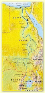
 Nile is the longest river in the world, stretching north for approximately 4,145 miles from East Africa to the Mediterranean. Studies have shown that the river gradually changed its location and size over millions of years. It flows from the mountains in the south to the Mediterranean in the north. Three rivers flowed into the Nile from the south and thus served as its sources : the Blue Nile, the White Nile, and the Arbara.Within the southern section between Aswan and Khartoum, land which is called Nubia, the river passes through formations of hard igneous rock, resulting in a series of rapids, or cataracts, which form a natural boundary to the south.Between first and second cataracts lay Lower Nubia, and between the second and sixth cataracts lay upper Nubia.At Aswan north of the first cataract the Nile is deeper and its surface is smoother.
The southern Egypt thus being upstream , is callled upper Egypt and northern Egypt being downstream and the delta called lower Egypt In addition to the valley and the delta, the Nile also divided Egypt into the Eastern and Western Deserts. The Nile valley is a canyon running 660 miles longwith a flood plain occupying 4,250 sq.miles.The delta spans some 8,500 sq,miles
and is fringed in its coastal regions by lagoons , wetlands, lakes and sand dunes.
 There were several major oeses of the western desert , which comprised about 2/3 of Egypt:and which increasingly became densely populated and agriculurally productive. The eastern Desert was esxploited in Pharaonic times for its rich minerals.The mere mention of the names of the Nile evokes for modern man images of Pyramids, great temples, fantastic tales of mummies and wondrous treasures. But Nile itself is the life to the people of Egypt. The river filled all areas of life with symbolism.

 from the earliest times, the waters of the Nile swollen by monsoon rains in Ethiopia, flooded over the surrounding valley every year between June and Sept. of the modern calender.
 The ancient Egyptian calender, made up of twelve months of 30 days each, was divided into three seasons, based upon the cycles of the Nile. The three seasons were : akhhet, Inundation, peret, the growing season and shemu, the drought or harvest season. During the season of the Inundation, layers of fertile soil were anually deposited on the floodplain . Chemical analysis habe shown how fertile the land due to the fertile Nile mud, which contains about 0.1p.c. of combined nitrogen, 0.2 p.c. of phosphates anhydrides, and o.6 p.c. of potassium.

.jpg)


 Sudan includes islands located in the Nile (including Aba, Badien, Sai, and the confluence of the Blue and white Nile, Tuti islands) and in the Red Sea (including the Suakin Archipelago).

 There were several major oeses of the western desert , which comprised about 2/3 of Egypt:and which increasingly became densely populated and agriculurally productive. The eastern Desert was esxploited in Pharaonic times for its rich minerals.The mere mention of the names of the Nile evokes for modern man images of Pyramids, great temples, fantastic tales of mummies and wondrous treasures. But Nile itself is the life to the people of Egypt. The river filled all areas of life with symbolism.
 from the earliest times, the waters of the Nile swollen by monsoon rains in Ethiopia, flooded over the surrounding valley every year between June and Sept. of the modern calender.
  The ancient Egyptian calender, made up of twelve months of 30 days each, was divided into three seasons, based upon the cycles of the Nile. The three seasons were : akhhet, Inundation, peret, the growing season and shemu, the drought or harvest season. During the season of the Inundation, layers of fertile soil were anually deposited on the floodplain . Chemical analysis habe shown how fertile the land due to the fertile Nile mud, which contains about 0.1p.c. of combined nitrogen, 0.2 p.c. of phosphates anhydrides, and o.6 p.c. of potassium.
.jpg)


 Sudan includes islands located in the Nile (including Aba, Badien, Sai, and the confluence of the Blue and white Nile, Tuti islands) and in the Red Sea (including the Suakin Archipelago).
The most important geographical feature of the country is the river Nile.