Geography of Switzerland
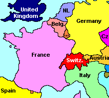 | Location | Central Europe south of Germany east of France north of Italy west of Austria |
|---|---|---|
| Coordinates | 47 00 N, 8 00 E | |
| Total Area | 41,293 km² (15,943 sq mi) | |
| · Area, water | 1,520 km² (587 sq mi) | |
| · Area, land | 39,773 km² (15,356 sq mi) |
Switzerland, a small country in the heart of western Europe, is not only the land of the Alps with some of the highest mountains in Europe (17 peaks above 4,000 m = 13,100 ft above sea level and many more between 2,000 and 4,000 m), it has also a plateau and many lakes.
While some 60% of Switzerland are in the alpine region (stretching from the Lake of Geneva in the southwest to Grisons in the southeast), another 30% are hills and relatively flat valleys carved out by glaciers called "Mittelland" [midlands] (400 to 900 m [1300 to 3000 ft] above sea level) stretching from the southwest (Lac Lé = Lake Geneva) to the northeast (Bodensee = Lake Constance). The remaining 10% form a chain of older mountains called Jura (along the western border to France, not exceeding 1,600 m [5300 ft] above sea level).
|
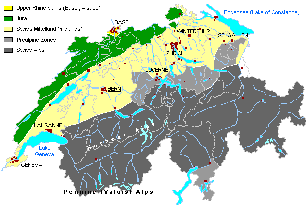
Map of Switzerland's major landscapes: Alps, Mittelland, Jura
Switzerland is highly industrialised and densely populated (7.1 million inhabitants, 170 per km² = 440 per sq.mile). Most of the cities, towns and larger villages are located in Mittelland - this means that the actual density of population in this part of the country is between 300 inhabitants per km² [800 per sq. mile] in "rural" areas and 500 inhabitants per km² [1300 per sq. mile] in metropolitan areas.
Swiss Rivers and Lakes
| Swiss Rivers & Lakes River Rhine River Aare River Reuss River Linth/Limmat River Rhône |