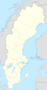
Sweden is a country in Northern Europe on the ScandinavianPeninsula. It borders Norway to the west; Finland to the northeast; and the Baltic Sea and Gulf of Bothnia to the east and south.
 Sweden has a long coastline on the eastern side and the Scandinavian mountain chain (Skanderna) on the western border, a range that separates Sweden from Norway. It has maritime borders with Denmark, Germany, Poland, Russia, Lithuania,Latvia and Estonia, and it is also linked to Denmark (southwest) by the Öresund Bridge. At 450,295 km2 (173,860 sq mi), Sweden is the 55th largest country in the world. It is the fifth largest in Europe and the largest in Northern Europe.
Sweden's natural resources include copper, gold, hydropower, iron ore, lead,silver, timber, uranium, and zinc.
Acid rain has become an issue because it is damaging soils and lakes and polluting the North Sea and the Baltic Sea. The HBV hydrology transport model has been used to analyze nutrient discharge to the Baltic from tributary watersheds.
Acid rain has become an issue because it is damaging soils and lakes and polluting the North Sea and the Baltic Sea. The HBV hydrology transport model has been used to analyze nutrient discharge to the Baltic from tributary watersheds.
Extreme points
The extreme points of Sweden include the coordinates that are farthest north, south, east and west in Sweden, and the ones that are at the highest and the lowest elevations in the country. In opposite to Norway and Denmark, Sweden has no external territories that can be considered either inside or outside the country depending on definition, meaning that the extreme points of Sweden are unambiguous.
The latitude and longitude are expressed in decimal degree notation, in which a positive latitude value refers to the northern hemisphere, and a negative value refers to the southern hemisphere. Additionally, a negative elevation value refers to land below sea level. The coordinates used in this article are sourced from Google Earth, which makes use of the World Geodetic System (WGS) 84, a geodetic reference system.
Latitude and longitude
Sweden's northernmost point is Treriksröset, in the Lapland province,[6] where the borders of Sweden, Norway, and Finland meet. The closest Swedish city to the area is Kiruna, which is Sweden's northern-most city. Sweden's southernmost point is in the harbour of the fishing village Smygehuk, near the city of Trelleborg, which borders the Baltic Sea. At the pier of the harbour, a signpost displays the exact position of the point, as well as the distance to Treriksröset, Stockholm, Berlin, Paris, and Moscow.
Sweden's westernmost point is on Stora Drammen, an islet in Skagerrakoutside the coast of Bohuslän. Seabirds and harbor seals have colonies on the islet, but it is uninhabited by humans. Sweden's easternmost point is on Kataja, an islet south of Haparanda in the Bothnian Bay. The islet is divided between Sweden and Finland. The border was established in 1809, after the Finnish War, between what was previously two islets, a Swedish one called Kataja and a smaller Finnish one called Inakari. Since 1809, post-glacial rebound has caused the sea level in the region to drop relative to land level, joining the two islets. If counting the mainland only, Stensvik in Strömstad is Sweden's westernmost point, and Sundholmen in Haparanda is the easternmost point.
| Heading | Location | Province | Bordering entity | Coordinates[16] | Ref |
|---|---|---|---|---|---|
| North | Treriksröset, Kiruna | Lapland | Troms, Norway, andLapland, Finland | 69.06°N 20.548611°E | [7][10][17] |
| South | Smygehuk,Trelleborg | Scania | Baltic Sea | 55.336944°N 13.359444°E | [9][10][18] |
| West | Stora Drammen,Strömstad | Bohuslän | Skagerrak | 58.928611°N 10.9575°E | [10][19][20] |
| West (mainland) | Stensvik, Strömstad | Bohuslän | Skagerrak | 58.997222°N 11.113056°E | [14][21][22] |
| East | Kataja, Haparanda | Norrbotten | Bothnian Bay | 65.710833°N 24.155833°E | [10][23][24] |
| East (mainland) | Sundholmen,Haparanda | Norrbotten | Torne River, and the Bothnian Bay | 65.815°N 24.150556°E | [15][17][25] |
Elevation
The highest point in Sweden is Kebnekaise, which stands at 2,104 metres (6,903 ft). It is in the Scandinavian Mountains chain, in the province of Lapland.[26][27] The mountain has two peaks, of which the glaciatedsouthern one is the highest at 2,104 metres (6,903 ft).[26] The northern peak, which stands at 2,096 metres (6,877 ft), is free of ice. Although the south top is traditionally said to be 2,111 metres (6,926 ft) high,[6] new measurements have shown that the glacier has shrunk; therefore the summit is not as high as earlier. Other points of comparable height in the vicinity of Kebnekaise include Sarektjåkka at 2,089 metres (6,854 ft), and Kaskasatjåkka at 2,076 metres (6,811 ft).
Sweden's lowest point, which is 2.41 metres (7.91 ft) below sea level, is in the Kristianstads Vattenrike Biosphere Reserve in the city of Kristianstad. The point is at the bottom of what was once Nosabyviken, a bay on the lake of Hammarsjön. The bay was drained in the 1860s by John Nun Milner, an engineer, to get morearable land for Kristianstad.
| Extremity | Name | Elevation | Location | Province | Coordinates[16] | Ref |
|---|---|---|---|---|---|---|
| Highest | Kebnekaise | 2,104 metres (6,903 ft) | Scandinavian Mountains | Lapland | 67.9°N 18.516667°E | [26][27][29] |
| Lowest | Kristianstads Vattenrike Biosphere Reserve | −2.41 metres (−7.91 ft) | Kristianstad | Scania | 56.021581°N 14.178878°E | [6][12][28] |


