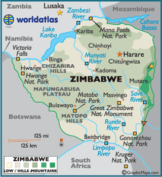
The area of Zimbabwe is about three times the size of England and nearly as big as Californea or Japan.Almost whole of the country lies more than 300 m above the sea level.The outstanding feature is the central plateau, known as the highveld,which is about 650km long by 80 km wide. on either side of this is the middleveld which is between 600m and 1,200m above sea level. Deep river valleys have split the Middleveld areas into great blocks of fine plateau country. The lowveld below 600 m comprises a narrow strip in the Zambezi Valley and a broader tract between ythe Limpopo and save rivers. The lowest point in the country is the confluence of the Save and Runde rivers which is about 162 m above sea level. Massive granite outcrops occur in various parts of Zimbabwe. Along the eastern border is a mountainous regiomn of great beauty, stretching for some 350 km . Towards the north of this region , the country's highest mountain, Inyangani, stands 2,592 kmabove sea level.