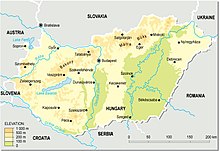
 With a land area of 93,033 square km, Hungary is a landlocked country in Central Europe. It measures about 250 km from north to south and 524 km from east to west. It has 2,258 km of boundaries, shared with Austria to the west, Serbia, Croatia and Slovenia to the south and southwest, Romania to the southeast, Ukraine to the northeast, and Slovakia to the north.
Hungary's modern borders were first established after World War I when, by the terms of the Treaty of Trianon in 1920, it lost more than 71% of what had formerly been the Kingdom of Hungary, 58.5% of its population, and 32% of the Hungarians. The country secured some boundary revisions from 1938 to 1941: In 1938 the First Vienna Award gave back territory from Czechoslovakia, in 1939 Hungary occupied Carpatho-Ukraine. In 1940 the Second Vienna Award gave back Northern Transylvania and finally Hungary occupied the Bácskaand Muraköz regions during the Invasion of Yugoslavia. However, Hungary lost these territories again with its defeat in World War II. After World War II, the Trianon boundaries were restored with a small revision that benefited Czechoslovakia.
Geography
Most of the country has an elevation of fewer than 200 m. Although Hungary has several moderately high ranges of mountains, those reaching heights of 300 m or more cover less than 2% of the country. The highest point in the country is Kékes (1,014 m) in the Mátra Mountains northeast of Budapest. The lowest spot is 77.6 m above sea level, located in the south of Hungary, near Szeged.
 The major rivers in the country are the Danube and Tisza. The Danube also flows through parts of Germany, Austria, Croatia, Slovakia,Serbia, and Romania.It is navigable within Hungary for 418 kilometers. The Tisza River is navigable for 444 km in the country. Less important rivers include the Drava along the Croatian border, the Rába, the Szamos, the Sió, and the Ipoly along the Slovakian border. Hungary has three major lakes. Lake Balaton, the largest, is 78 km long and from 3 to 14 km wide, with an area of 592 square km. Hungarians often refer to it as the Hungarian Sea. It is Central Europe's largest freshwater lake and an important recreation area. Its shallow waters offer good summer swimming, and in winter its frozen surface provides excellent opportunities for winter sports. Smaller bodies of water are Lake Velence (26 square km) in Fejér County and Lake Fertő (Neusiedler See—about 82 square km within Hungary).
Hungary has three major geographic regions (which are subdivided to seven smaller ones): the Great Alföld, lying east of the Danube River; the Transdanubia, a hilly region lying west of the Danube and extending to the Austrian foothills of the Alps; and the North Hungarian Mountains, which is a mountainous and hilly country beyond the northern boundary of the Great Hungarian Plain.
The country's best natural resource is fertile land, although soil quality varies greatly. About 70% of the country's total territory is suitable for agriculture; of this portion, 72% is arable land. Hungary lacks extensive domestic sources of energy and raw materials needed for industrial development.
