Monday, November 23, 2009

Sudan,Geography (cont-3)

As per physical features Sudan is divided in 6 regions. 1. North Sudan, 2. Darfar, 3. Eastern Front, 4. South Sudan, 5. Abyei, 6. Nuba mountains and Blue Nile.
1. Northern Sudan lying between the Egyptian border and Khartoum. It has two distinct parts, the desert and the Nile Valley.To the east there lies the Nubian Desert,and to the west, the Libyan Desert.There is virtually no rainfall in these desertsand in the Nubian desert there is no oesis also.In the west there are a few small watering holes, such as Bir, an Natrum. This portion of the Sudan is inadequate for human settlement.Only in a neighbourhood of Nile there are some healthy cities whose productivity depends on the annual flood.
Western Sudan is a generic term describing the regions known as Darfar and Kurdufan. The dominant feature of this region is the absence of surface water and the people and animal are to live with permanent wells. Hence the population is sparse and and unevenly distributed. The volcanic massif of Jabal Marrah exists in this region.The southern region of western Sudan has sand dumes in the rainy season is characterised by a rolling mantle of grass and has more reliable sources of water with its bore holes and hafri than does the north.
Sudan's third distinct region is the central clay plains that stretch eastward from the Nuba mountains to the Ethiopian Frontier broken by the Ingessana hills. From the Khartoum in the north to the to the far reaches of reachesof southern Sudan.In the heart line of the cenral clay plains lies the Jazirah, the lan between the blue Nile and the white Nile
Extending 100 kms north of Kassala, the whole area watered by Qash is a rich grassland with bountiful cultivation . Trees and bushes provide grazing for the camels from the north , and the rich moist soil provides an abondance of food crops and and cotton.
Northward beyond the qash lie the more formidable RedSea Hills. Dry, bleak, and cooler than the surounding land, particularly in the heat of the Sudan summer, they stretch northward into Egypt, a jumbled mass of hills sprawls the coastal plains of the Red Sea. The coastal plain is dry and barren . it consists of rocks , and the seaward side thick with coral reefs.
The southern clay plains which is the extension of the northern clay plains extends all the way from northern Sudan to the mountains on th Sudan-Uganda frontier.

Sunday, November 22, 2009

Sudan, Geography (contd-2)

East of the Nile valley is the Nubian desert, where permanent humn settlements becomes impossible. There along the Sudanese Red sea coasts, the Beja or the Medjay Nubian as known to the ancient Egyptians formed their own communities depending mainly on parture and subsistent agriculture in more southrly regions of el-Butana.
The Lybian desert , west of Nubia, is cossted of almost, endless stretches of sand-dunesthat dominate the landscape and continue across Sahara deserts of north and central africa.
Urban scene from the from the Nile valley near Khartoum Cluster of cities determine the habitation at Sudan

Around the Dangola Reach and south in the Bayuda desert are also plenty of pastural lands. From Abu hamed to to the city of Berber south, the Nile valley becomes less fertile.However, immedialetly south of, the city of Berber the Nile valley becomes fertile and supportive for extensive agriculture.

Saturday, November 21, 2009

Sudan, Geography (contd-1)

The White and blue Nile converge at Khartoum (capital of Sudan) and the historic Omdurman Bridge.
Villagers crossing the Nile, northern Sudan Five Cataracts interrupt the flow of the Nile from south of Aswan to little north of the city of Berber in Central Sudan. This makes sailing impossible except for the short distance that separate from one cataract to the other. Agricultural lands are available in the Dongola Reach and along the curve of the nile valley as far south as Abu Hamed. this fertile region of the Nile valley produced enough agricultural supply for prominent Nubian kingdoms and cities to develop.

Nubian Herder (Sudan) Nubia is part of modern day country of Sudan. Howeaver, historically the land of Nubia Stretches from Aswan (the modern day the country of Egypt) in the north of Kosti in the White Nile and Sinnar in the Blue Nile in the south, and from the red sea coast to Kordofan and the Libyan desert in the west. Most of Sudan's topography is consisted of the Nile valleywhich provide fertile agriculture and abondant pasture for settled human communities. Because of the availability of food along the nile valley human community there grew in number more than in any other location in Sudan. As a result the first unified civilisation in the world developed there.
However unlike the Nile valley of Egypt many portions of the Nile valley in Nubia are and were not supportive for extensive agriculture as a result pasture was a main source of food for the Nubians more than the ancient Egyptians. From Aswan to Lower Wadi Halfa the Nile cut through a barren stretch of desert that is not sopportive for the living of any sort of human community.

Thursday, November 19, 2009

Sudan, Natuaral Resources and Rivers

Nile is the dominant geographic feature of Sudan, flowing 3,000 kms from Uganda in the south to Egypt in the north.ost of the countries lies within its catchment basin . The blue Nile and the white Nile , originating in the Ethiopian highlands and the Central Africans lakes, respectively, join at Khartoum to form the Nile River proper that flows to Egypt. Other major tributaries of the Nile are the Bahr el Ghazal, Sobat, and Atbarah rivers.
Sudan's total lands area amounts to some 2,510,000 Km sq. About half of this land is suitable for agriculture , of which about 170,000 km sq. are actually cultivated.
1993 estimates:
* 5% arable land
* o% Permanent crops
* 46 % permanent pastures
* 19 % forests and woodland
* 30 % other areas
* 19, 460 Km sq. irrigated land.
Petroleum is major natural resoure 0f Sudan. It has also small deposits of Chromium ore , copper ,gold, iron, mica,silver , tungstan, and zinc.

Sudan, Geography

The republic of Sudan is the largest country in Africa. Most of Sudan occupies a great plain rimmed by hills and mountains everywhere but on the north. From elevations of 2,000 to 3,000 feet above sea level along the edges, the plain drops gradually along the north.
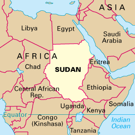
Sudan has its north as Egypt, Red Sea and Libya, in the west Chad, Central AfricanRepublic, in the south Uganda, Kenya, in the east Eritrea,Ethiopia.


Northern Sudan lies within the Sahara , and includes part of the sandy, almost uninhabited Libyan desert and all of the Nubian desert. Separating the desert plains from the coast are thew barren Red sea hills, whose highest peaks rise to slightly more than 7,000 ft . A t about the latitude of Khartoum, Sudan's capital, the desert begins to merge with grassland that covers much of the central part of the country. Breaking the monotonous expanse of plain are the low Nuba Mountains, whose peaks reach 10,000 ft .

Southern Sudan is largely a region of swamps, savannas, and tropical forests.entered on the southern White Nile valleyis the Sudd


Sudan, Introduction

Sudan is located in the
northeastern africa. It
borders the Red Sea
betwenn Egypt and Eritrea.It has a length of 7,687 kms and borders with Central African Republic, Chad, Dem.Rep. of the Congo,Egypt, Eritrea, Ethiopia, Kenya, Libya, and Uganda. It is just above the poverty line with rank 167 and Av. per capita income atlas method 2003 est is 460 US $. In other methods of measurement WB,IMF and CIA
its rank/Measure is est.2007
WB 125/1,244-2007 est.
IMF-118/1,235
CIA-129/1,172.