Norway is a country located in Northern Europe on the western and northern part of the Scandinavian Peninsula, bordering the North Sea in southwest and the Skagerrak inlet to the south, the North Atlantic Ocean (Norwegian Sea) in the west and the Barents Sea to the northeast. Norway has a long land border with Sweden to the east, a shorter one withFinland in the northeast and a still shorter border with Russiain the far northeast.
Norway has a very elongated shape, one of the longest and most rugged coastlines in the world, and some 50,000 islands off the extremely indented coastline. The mainland covers 13° latitude, from 58°N to more than 71°N, (Svalbardnorth to 81°N), and covers the longitude from 5°E in Solund to31°E in Vardø (Jan Mayen to 9°W, Kvitøya to 33°E).
Norway is one of the world's most northerly countries, and one of Europe's most mountainous countries with large areas dominated by the Scandinavian Mountains; average elevation is 460 m and 32% of the mainland is located above the tree line.
The country-length chain of peaks is geologically continuous with the mountains of Scotland, Ireland and, crossing theAtlantic Ocean, the Appalachian Mountains of North America. Geologists hold that all these formed a single range prior to the breakup of the ancient supercontinent Pangaea.
Virtually the entire country was covered with a thick ice sheetduring the last ice age, as well as in many earlier ice ages. The movement of the ice carved out deep valleys, and when the ice melted, the sea filled many of these valleys, creating Norway's famous fjords.
The land is still rebounding from the enormous weight of the ice (isostatic rebound), "growing out of the sea" with several mm a year, especially the eastern part of the country and the inner part of the long fjords, where the ice cover was thickest. This is a slow process, and for thousands of years following the end of the ice age, the sea covered substantial areas of what is today dry land. The sea reached what is today an elevation of 221 m in Oslo (Aker), 25 m in Stavanger, 5 m near Stad, 180 m in Trondheim, 50 m in Tromsø and 75 m inKirkenes. This old seabed is now among the best agricultural land in the country.
The glaciers in the higher mountain areas today are not remnants of the large ice sheet of the ice age, their origins are more recent. The regional climate was up to 1-3 °C warmer in 7000 B.C. to 3000 B.C. in the Holocene climatic optimum, (relative to the 1961-90 period), melting the remaining glaciers in the mountains almost completely during that period.
As a result of the ice carving, Sognefjorden is the world's second deepest fjord and Hornindalsvatnet is the deepest lake in Europe.
[edit]
Scandinavian Mountains. The Scandinavian Mountains are the most defining feature of the country. Starting with Setesdalsheiene north of the southern Skagerrak coast, the mountains goes north, comprising large parts of the country, and intersected by the many fjords of Vestlandet. This part includes Hardangervidda,Jotunheimen (with Galdhøpiggen 2469 m), Sognefjell and Trollheimen in the north, with large glaciers, such asJostedalsbreen, Folgefonna and Hardangerjøkulen. The mountain chain swings eastwards south of Trondheim, with ranges such as Dovrefjell and Rondane, and reaches to the border with Sweden, where they are mostly gently sloping plateaus. The mountains then follows the border in a northeasterly direction (known as Kjølen). The mountains are intersected by many fjords in Nordland and Troms, where they become more alpine and creates many islands as they meet the sea. The Scandinavian mountains forms the Lyngen Alps and reaches into northwestern Finnmark, gradually becoming lower from Altafjord towards Nordkapp (North Cape), where they finally ends at the shores of the Barents sea.
The Scandinavian Mountains have naturally divided the country in physical regions; valleys radiate from the mountains in all directions. The following physical regions will only partially correspond to traditional regions and counties in Norway.
Southern coast. The southern Skagerrak and North Sea coast is the lowland south of the mountain range, from Stavanger in the west to the western reaches of the outer part of the Oslofjord in the east. In this part of the country, valleys tend to follow a north - south direction. This area is mostly a hilly area, but with some very flat areas such as Lista and Jæren.
Southeast. The land east of the mountains (corresponding to Østlandet, most of Telemark andRøros) is dominated by valleys going in a north - south direction in the eastern part, and a more northwest - southeast direction further west, and the valleys congregate on the Oslofjord. The longest valleys in the country are Østerdal and Gudbrandsdal. This part also contains larger areas of lowland surrounding the Oslofjord, as well as the Glomma river and lake Mjøsa.
Western fjords. The land west of the mountains (corresponding to Vestlandet north of Stavanger) is more dominated by the mountain chain, as the mountains goes all the way to the coast, albeit gradually becoming lower towards the coast. This part is dominated by large fjords, the largest are Sognefjord and Hardangerfjord. Geirangerfjord is often regarded as the ultimate fjord scenery. The coast is protected by a chain of skerries (the Skjærgård) arranged to parallel the coast and provide the beginning of a protected passage almost the entire 1,600 km route from Stavanger to Nordkapp. The fjords and most valleys generally goes in a west - east direction, and further north a more northwest - southeast direction. Trondheim region. The land north of Dovre (corresponding to Trøndelag except Røros) comprises a more gentle landscape with more rounded shapes and mountains, and with valleys congregating on the Trondheimsfjord, where they open up and forms a larger lowland area. Further north is the valley of Namdalen, opening up in the Namsos area. However, the Fosenpeninsula, and the most northern coast (Leka) is more dominated by mountains and more narrow valleys.
Northern fjords. The land further north (corresponding to Nordland, Troms and northwestern Finnmark) is again more dominated by pointed mountains going all the way to the coast, and numerous fjords. The fjords and valleys generally lie in a west - east direction in the southern part of this area, and a more northwest - southeast direction further north. The Saltfjelletmountain range is an exception, as the valleys goes in a more north - south direction from these mountains. This long area comprises many large islands, including Lofoten,Vesterålen and Senja.
Far northeast. The interior and the coast east of Nordkapp (corresponding to Finnmarksvidda and eastern Finnmark) is less dominated by mountains, and is mostly below 400 m. The interior is dominated by the large Finnmarksvidda plateau. There are large, wide fjords going in a north - south direction. This coast lacks the small islands forming the skerries so typical of the Norwegian coast. Furthest to the east, the Varangerfjordgoes in an east - west direction, and is the only large fjord in the country opening up towards the east.
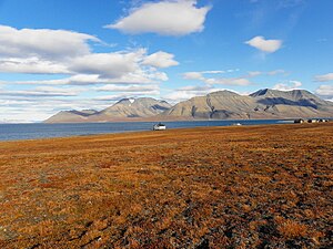
Svalbard. Further north, in the Arctic ocean, lies the Svalbard archipelago, which is also dominated by mountains, but these mountains are mostly covered by large glaciers, especially the eastern part of the archipelago, where glaciers cover more than 90%; Austfonna is the largest glacier in Europe. Unlike the mainland, these glaciers calves directly in the open ocean.
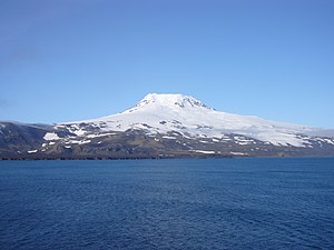
Jan Mayen. To the far northwest, halfway towards Greenland, is the island Jan Mayen, where Beerenberg is found, the only active volcano in Norway.
Bouvet Island. Located in the South Atlantic Ocean at 54°S and mostly covered by glaciers, this island is one of the most remote islands in the world, inhabited only by seals and birds.
Peter I Island. This island in the South Pacific Ocean at 69°S, 90°W is dominated by glaciers and a volcano. As with Bouvet Island, this island is regarded as an external dependency, and not part of the Kingdom.
Queen Maud Land is Norway's claim in Antarctica. This large, sectorial area stretches to the South Pole and are completely dominated by the world's largest ice sheet, but with some impressive nunataks penetrating above the ice. The Troll Research Station manned by Norway is located on a snow free mountain slope, the only station in Antarctica not to be located on the ice.


