Friday, May 31, 2013

Rivers and Lakes of Egypt

The Nile  is a major north-flowing river in northeastern Africa, generally regarded as the longest river in the world. It is 6,650 km (4,130 miles) long. The Nile is an "international" river as its water resources are shared by eleven countries, namely, Tanzania, Uganda, Rwanda, Burundi, Democratic Republic of the Congo, Kenya, Ethiopia, Eritrea, South Sudan, Sudan and Egypt.[4] In particular, the Nile River provides the primary water resource and so it is the life artery for its downstream countries such as Egypt and Sudan.[5]
The Nile has two major tributaries, the White Nile and Blue Nile. The White Nile is longer and rises in the Great Lakes region of central Africa, with the most distant source still undetermined but located in either Rwanda or Burundi. It flows north through Tanzania, Lake Victoria, Uganda and South Sudan. The Blue Nile is the source of most of the water and fertile soil. It begins at Lake Tana in Ethiopia at
WikiMiniAtlas
12°02′09″N 037°15′53″E / 12.03583°N 37.26472°E / 12.03583; 37.26472 and flows into Sudan from the southeast. The two rivers meet near the Sudanese capital of Khartoum.

The northern section of the river flows almost entirely through desert, from Sudan into Egypt, a country whose civilization has depended on the river since ancient times. Most of the population and cities of Egypt lie along those parts of the Nile valley north of Aswan, and nearly all the cultural and historical sites of Ancient Egypt are found along riverbanks. The Nile ends in a large delta that empties into the Mediterranean Sea.\
This is a list of rivers in Egypt.
There is only one year-round river in Egypt, the Nile. It has no non-seasonal tributaries for its entire length in Egypt, though it has two further upstream, the Blue Nile and White Nile, which merge in central Sudan.
In the Nile Delta, the river splits into a number of distributaries and lesser channels. In ancient times there were seven distributaries, of which only two are extant today due to silting and flood relief schemes; from east to west, they were:
  • the Pelusiac,
  • the Tanitic,
  • the Mendesian,
  • the Phatnitic (extant; now the Damietta or Damyat),
  • the Sebennytic,
  • the Bolbitinic,
  • the Canopic (extant; now the Rosetta or Rashid).
The Nile is intersected by a number of normally dry tributaries or wadis which traverse the Eastern Desert. The wadis drain run-off rainfall from the mountains along the Egyptian Red Sea coast, though it only rarely reaches the main trunk of the wadis to flow downstream to the Nile. The three principal wadis are:

Wednesday, May 29, 2013

Physical Geography of Egypt (contd-1)

2. Western Desert

The Western Desert covers an area of some 700,000 km2, thereby accounting for around two-thirds of Egypt's total land area. This immense desert to the west of the Nile spans the area from the Mediterranean Sea southwards to the Sudanese border. The desert's Jilf al Kabir Plateau, at a mean altitude of some 1000 m, constitutes an exception to the uninterrupted territory of basement rocks covered by layers of horizontally bedded sediments forming a massive plain or low plateau. The Great Sand Sea lies within the desert's plain and extends from the Siwa Oasis to Jilf al Kabir. Escarpments (ridges) and deep depressions (basins) exist in several parts of the Western Desert, and no rivers or streams drain into or out of the area.
The government has considered the Western Desert a frontier region and has divided it into two governorates at about the twenty-eighth parallel: Matruh to the north and New Valley (Al Wadi al Jadid) to the south. There are seven important depressions in the Western Desert, and all are considered oases except the largest, Qattara, the water of which is salty. The Qattara Depression, which includes the country's lowest point, encompasses 19,605 square kilometers (7,570 sq mi), which is similar to the size of Lake Ontario. It is largely below sea level and is 133 meters (436 ft) below sea level at the lowest. Badlands, salt marshes, and salt lakes cover the sparsely inhabited Qattara Depression.
Limited agricultural production, the presence of some natural resources, and permanent settlements are found in the other six depressions, all of which have fresh water provided by the Nile or by local groundwater. The Siwah Oasis, close to the Libyan border and west of Qattara, is isolated from the rest of Egypt but has sustained life since ancient times. The Siwa's cliff-hung Temple of Amun was renowned for its oracles for more than 1,000 years. Herodotus and Alexander the Great were among the many illustrious people who visited the temple in the pre-Christian era.
The other major oases form a topographic chain of basins extending from the Faiyum Oasis (sometimes called the Fayyum Depression) which lies 60 kilometers (37 mi) southwest of Cairo, south to the Bahariya, Farafirah, and Dakhilah oases before reaching the country's largest oasis, Kharijah. A brackish lake, Birket Qarun, at the northern reaches of Al Fayyum Oasis, drained into the Nile in ancient times. For centuries sweetwater artesian wells in the Fayyum Oasis have permitted extensive cultivation in an irrigated area that extends over 1,800 square kilometers (695 sq mi).

3. Eastern Desert


A large plume of Saharan Desert dust (light brownish pixels) blown across Libya and Egypt northward over the Mediterranean Sea toward the Middle East, on February 2, 2003.
The topographic features of the desert region east of the Nile differ from those to the west of the Nile. The Eastern Desert is relatively mountainous. The elevation rises abruptly from the Nile, and an upward-sloping plateau of sand gives way within 100 km to arid, defoliated, rocky hills running north and south between the Sudan border and the Delta. The hills reach elevations of more than 1,900 m. The region's most prominent feature is the easterly chain of rugged mountains, the Red Sea Hills, which extend from the Nile Valley eastward to the Gulf of Suez and the Red Sea. This elevated region has a natural drainage pattern that rarely functions because of insufficient rainfall. It also has a complex of irregular, sharply cut wadis that extend westward toward the Nile. The desert environment extends all the way to the Red Sea coast.
The Eastern Desert covers an area of approximately 220,000 km2. The area is essentially uninhabited. There are no oasis cultivation centers. Not counting settlements on the Red Sea coast, there are no permanent towns or villages in the area at all. The Eastern Desert has some petroleum resources in the north, a center for which is at Ras Gharib on the Gulf of Suez coast. A single Egyptian governorate, the Red Sea Governorate, administers the entire region. The administrative capital is on the Red Sea coast at Al Ghardaqah (aka Hurgada).

5. Sinai Peninsula


Mount Catherine in Sinai, the country's highest point
The Sinai Peninsula is a triangular-shaped peninsula, about 61,100 km2 in area (slightly smaller than the U.S. state of West Virginia). Similar to the desert, the peninsula contains mountains in its southern sector that are a geological extension of the Red Sea Hills, the low range along the Red Sea coast that includes Mount Catherine (Jabal Katrinah), the country's highest point, at 2,642 m above sea-level. The Red Sea may have been named after these mountains, which are red.
The southern side of the peninsula has a sharp escarpment that subsides after a narrow coastal shelf that slopes into the Red Sea and the Gulf of Aqaba. The elevation of Sinai's southern rim is about 1,000 m. Moving northward, the elevation of this limestone plateau decreases. The northern third of Sinai is a flat, sandy coastal plain, which extends from the Suez Canal into the Gaza Strip and Israel.
Before the Israeli military occupied Sinai during the June 1967 War (Arab-Israeli war, also known as the Six-Day War), a single Egyptian governorate administered the whole peninsula. By 1982 after all of Sinai was returned to Egypt, the central government divided the peninsula into two governorates. North Sinai has its capital at Al Arish and the South Sinai has its capital in Artt Turkishy.

Oasis in Geography

In geography, an oasis (plural: oases) or cienega (Southwestern United States) is an isolated area of vegetation in a desert, typically surrounding a spring or similar water source. Oases also provide habitat for animals and even humans if the area is big enough. The location of oases has been of critical importance for trade and transportation routes in desert areas. Caravans must travel via oases so that supplies of water and food can be replenished. Thus, political or military control of an oasis has in many cases meant control of trade on a particular route. For example, the oases of Awjila, Ghadames and Kufra, situated in modern-day Libya, have at various times been vital to both North-South and East-West trade in the Sahara.

An oasis in the Negev Desert of Israel.
Oases are formed from underground rivers or aquifers such as an artesian aquifer, where water can reach the surface naturally by pressure or by man made wells. Occasional brief thunderstorms provide subterranean water to sustain natural oases, such as the Tuat. Substrata of impermeable rock and stone can trap water and retain it in pockets, or on long faulting subsurface ridges or volcanic dikes water can collect and percolate to the surface. Any incidence of water is then used by migrating birds who also pass seeds with their droppings which will.
 
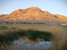
The lush Middle Springs, with the barren desert around Fish Springs NWR in Utah

Contents

Etymology

The word oasis comes into English via Latin: oasis from Ancient Greek: ὄασις óasis, which in turn is a direct borrowing from Demotic Egyptian. The word for oasis in the later attested Coptic language (the descendant of Demotic Egyptian) is wahe or ouahe which means a 'dwelling place'.[1]

Oasis in the Libyan part of the Sahara

Growing plants

People who live in an oasis must manage land and water use carefully; fields must be irrigated to grow plants like dates, figs, olives, and apricots. The most important plant in an oasis is the date palm, which forms the upper layer. These palm trees provide shade for smaller trees like peach trees, which form the middle layer. By growing plants in different layers, the farmers make best use of the soil and water. Many vegetables are also grown and some cereals, such as wheat, barley and millet, are grown where there is more moisture.[2]

Notable oases

Africa

North America and South America


Asia

Australia

Physical Geography of Egypt

1. Nile Valley and Delta
The Nile Valley and Delta, the most extensive oasis on earth, was created by the world's longest river and its seemingly inexhaustible sources. Without the topographic channel that permits the Nile to flow across the Sahara, Egypt would be entirely desert. The length within Egypt of the River Nile in its northwards course from three central African sources – the White Nile, the Blue Nile, and the Atbara – totals some 1,600 km.
The White Nile, which begins at Lake Victoria in Uganda, supplies about 28% of the Nile's Egyptian waters. In its course from Lake Victoria to Juba in southern Sudan, the White Nile's channel drops more than 600 m. In its 1,600-km course from Juba to Khartoum, Sudan's capital, the river descends just 75 m. In southern and central Sudan, the White Nile passes through a wide, flat plain covered with swamp vegetation and slows almost to the point of stagnation.
The Blue Nile, which originates at Lake Tana in Ethiopia, provides on average some 58% of the Nile's Egyptian waters. This river has a steeper gradient and therefore flows more swiftly than the White Nile, which it joins at Khartoum. Unlike the White Nile, the Blue Nile carries a considerable amount of sediment. For several kilometres north of Khartoum, water closer to the eastern bank of the river, coming from the Blue Nile, is visibly muddy, while that closer to the western bank, and coming from the White Nile, is clearer.
The much shorter Atbara River, which also originates in Ethiopia, joins the main Nile north of Khartoum between the fifth and sixth cataracts (areas of steep rapids) and provides about 14% of the Nile's waters in Egypt. During the low-water season, which runs from January to June, the Atbarah shrinks to a number of pools. But, in late-summer, when torrential rains fall on the Ethiopian plateau, the Atbarah provides 22% of the Nile's flow.
The Blue Nile has a similar pattern. It contributes 17% of the Nile's waters in the low-water season and 68% during the high-water season. In contrast, the White Nile provides only 10% of the Nile's waters during the high-water season but contributes more than 80% during the low-water period. Thus, before the Aswan High Dam was completed in 1971, the White Nile watered the Egyptian stretch of the river throughout the year, whereas the Blue Nile, carrying seasonal rain from Ethiopia, caused the Nile to overflow its banks and deposit a layer of fertile mud over adjacent fields. The great flood of the main Nile usually occurred in Egypt during August, September, and October, but it sometimes began as early as June at Aswan and often did not completely wane until January.
The Nile enters Egypt a few kilometres north of Wadi Halfa, a Sudanese town that was completely rebuilt on high ground when its original site was submerged in the reservoir created by the Aswan High Dam. As a result of the dam's construction, the Nile actually begins its flow into Egypt as Lake Nasser, which extends southwards from the dam for 320 km to the border and for an additional 158 km within Sudan. Lake Nasser's waters fill the area through Lower Nubia (Upper Egypt and northern Sudan) within the narrow canyon between the cliffs of sandstone and granite created by the flow of the river over many centuries. Below Aswan the cultivated floodplain strip widens to as much as twenty km. North of Isna (160 km north of Aswan), the plateau on both sides of the valley rises to as much as 550 m above sea level; at Qina (some 90 km north of Isna) the 300-m limestone cliffs force the Nile to change course towards the southwest for about 60 km before it turns northwest for about 160 km to Asyut. Northward from Asyut, the escarpments on both sides diminish, and the valley widens to a maximum of 22 km.
At Cairo, the Nile spreads out over what was once a broad estuary, subsequently filled by silt deposits to form what is now a fertile, fan-shaped delta some 250 km wide at its seaward extremity and extending about 160 km from north to south. The Nile Delta covers approximately 22,000 km2 (roughly equivalent in area to that of Massachusetts). According to historical accounts from the first century AD, seven branches of the Nile once ran through the delta. According to later accounts, the Nile had, by around the twelfth century, just six branches. Since then, nature and man have closed all but two main outlets: the east branch, Damietta (also seen as Dumyat; 240 km long), and the west branch, Rosetta (235 km long). Both outlets are named after the ports located at their respective mouths. A network of drainage and irrigation canals supplements these remaining outlets. In the north, near the coast, the Nile delta embraces a series of salt marshes and lakes, the most notable among which are Idku, Al Burullus, and Manzilah.
The fertility and productivity of the land adjacent to the Nile depends largely on the silt deposited by floodwaters. Archaeological research indicates that people once lived at a much higher elevation along the river than they do today, probably because the river was higher or the floods more severe. The timing and the amount of annual flow were always unpredictable. Measurements of annual flows as low as 1.2 billion m3 and as high as 4.25 billion m3 have been recorded. For centuries Egyptians attempted to predict and take advantage of these flows and thereby moderate the severity of floods.
The construction of dams on the Nile, particularly the Aswan High Dam, transformed the mighty river into a large and predictable irrigation ditch. Lake Nasser, the world's largest artificial lake, has enabled planned use of the Nile regardless of the amount of rainfall in Central Africa and East Africa. The dams have also affected the Nile Valley's fertility, which was dependent for centuries not only on the water brought to the arable land but also on the materials left by the water. Researchers have estimated that beneficial silt deposits in the valley began about 10,000 years ago. The average annual deposit of arable soil through the course of the river valley amounted to some nine metres. Analysis of the flow revealed that 10.7 million tons of solid matter passed Cairo each year. Today the Aswan High Dam obstructs most of this sediment, now retained in Lake Nasser. The reduction in annual silt deposits has contributed to rising water tables and increasing soil salinity in the Delta, the erosion of the river's banks in Upper Egypt, and the erosion of the alluvial fan along the shore of the Mediterranean Sea

Tuesday, May 28, 2013

Geography of Egypt


The Geography of Egypt relates to two regions: Southwest Asia and North Africa.
Egypt has coastlines on both the Mediterranean Sea and the Red Sea. The country borders Libya to the west, the Gaza Strip and Israel to the east, and Sudan to the south. Covering 1,001,449 km2, Egypt has a land area about the same as that of Texas and New Mexico combined, four times bigger than that of the United Kingdom, and twice as big as that of France. The longest straight-line distance in Egypt from north to south is 1,024 km, while that from east to west measures 1,240 km. More than 2,900 km of coastline on the Mediterranean Sea, the Gulf of Suez, the Gulf of Aqaba and the Red Sea constitute Egypt's maritime boundaries.
Egypt is predominantly desert. Only 35,000 km2 - 3.5% - of the total land area is cultivated and permanently settled. Most of the country lies within the wide band of desert that stretches eastwards from Africa's Atlantic Coast across the continent and into southwest Asia.
Egypt's geological history has produced four major physical region
Despite covering only about 5.5% of the total area of Egypt, the Nile Valley and Nile Delta are the most important regions, being the country's only cultivable regions and supporting about 99% of the population. The Nile valley extends approximately 800 km from Aswan to the outskirts of Cairo. The Nile Valley is also known as Upper Egypt, while the Nile Delta region is known as Lower Egypt. Steep rocky cliffs rise along the banks of the Nile in some stretches, while other areas along the Nile are flat, with space for agricultural production. In the past, flooding of the Nile during the summer provided silt and water to make agriculture possible on land that is otherwise very dry. Since construction of the Aswan Dam, agriculture in the Nile valley depends on irrigation. The Nile delta consists of flat, low-lying areas. Some parts of the delta are marshy and water-logged, and thus not suitable for agriculture. Other areas of the delta are used for agriculture.

Monday, May 27, 2013

Hanging Church of Cairo

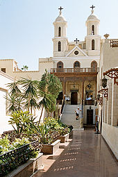
Saint Virgin Mary's Coptic Orthodox Church also known as the Hanging Church (El Muallaqa) is one of the oldest churches in Egypt and the history of a church on this site dates to the 3rd century AD.
The Hanging (The Suspended) Church is named for its location above a gatehouse of Babylon Fortress, the Roman fortress in Coptic Cairo (Old Cairo); its nave is suspended over a passage. The church is approached by 29 steps; early travelers to Cairo dubbed it "the Staircase Church." The land surface has risen by some 6 metres since the Roman period so that the Roman tower is mostly buried below ground, reducing the visual impact of the church's elevated position. The entrance from the street is through iron gates under a pointed stone arch. The nineteenth-century facade with twin bell towers is then seen beyond a narrow courtyard decorated with modern art biblical designs. Up the steps and through the entrance is a further small courtyard leading to the eleventh-century outer porch.
The Hanging Church is the most famous Coptic Christian church in Cairo, as well as possibly the first built in Basilican style. It was probably built during the patriarchate of Isaac (690–92), though an earlier church building may have existed elsewhere dating as early as the 3rd or 4th century. However, the earliest mention of the church was a statement in the biography of the patriarch Joseph I (831–49), when the governor of Egypt visited the establishment. The church was largely rebuilt by the Pope Abraham (975–78) and has seen many other restorations including one very recently, after which objects of historical interest that were no longer of service went to the Coptic Museum.
The Seat of the Coptic Orthodox Pope of Alexandria was, historically, Alexandria, Egypt. But as ruling powers moved away from Alexandria to Cairo after the Arab invasion of Egypt during Pope Christodolos's tenure, Cairo became the fixed and official residence of the Coptic Pope at the Hanging Church in Cairo in 1047.
Infighting between the Church of Saints Sergius and Bacchus and the El Muallaqa Church broke out due to the wishes of that patriarch's desire to be consecrated in the Hanging Church, a ceremony that traditionally took place at Saints Sergius and Bacchus.
The Hanging Church has 110 icons, the oldest of which dates back to the 8th century, but most of them date to the 18th century. Nakhla Al-Baraty Bey gave some of them as gifts, in 1898, when he was the overseer of the church.[3] The iconostasis of the central sanctuary is made of ebony inlaid with ivory, and is surmounted by icons of the Virgin Mary and the Twelve Apostles. The main altar (Egyptian Arabic: haikal) screen is made of ebony inlaid with ivory that is carved into segments showing several Coptic Cross designs that date back to around the 12th or 13th century. Over the altar screen lies a long row of seven large icons, the central one of which is Christ seated on the Throne. On one side, the icons of the Virgin Mary, Archangel Gabriel and St Peter are lined up. On the other, icons of St. John the Baptist, Archangel Michael and St. Paul.

European invasion in Egypt

Portuguese traders took over their trade.famine cost it roughly one-sixth of its population.
( Egypt-Cairo,_Old_Cairo,_Hanging_Church,_Egypt,_Oct_2004)
Egypt suffered six famines between 1687 and 1731. The 1784
The brief French invasion of Egypt led by Napoleon Bonaparte began in 1798. The expulsion of the French in 1801 by Ottoman, Mamluk, and British forces was followed by four years of anarchy in which Ottomans, Mamluks, and Albanians — who were nominally in the service of the Ottomans — wrestled for power. Out of this chaos, the commander of the Albanian regiment, Muhammad Ali (Kavalali Mehmed Ali Pasha) emerged as a dominant figure and in 1805 was acknowledged by the Sultan in Istanbul as his viceroy in Egypt; the title implied subordination to the Sultan but this was in fact a polite fiction: Ottoman power in Egypt was finished and Muhammad Ali, an ambitious and able leader, established a dynasty that was to rule Egypt until the revolution of 1952. In later years, the dynasty became a British puppet.
His primary focus was military: he annexed Northern Sudan (1820–1824), Syria (1833), and parts of Arabia and Anatolia; but in 1841 the European powers, fearful lest he topple the Ottoman Empire itself, forced him to return most of his conquests to the Ottomans, but he kept the Sudan and his title to Egypt was made hereditary. A more lasting result of his military ambition is that it required him to modernize the country. Eager to adopt the military (and therefore industrial) techniques of the great powers, he sent students to the West and invited training missions to Egypt. He built industries, a system of canals for irrigation and transport, and reformed the civil service.
The introduction in 1820 of long-staple cotton, the Egyptian variety of which became notable, transformed its agriculture into a cash-crop monoculture before the end of the century. The social effects of this were enormous: land ownership became concentrated and many foreigners arrived, shifting production towards international markets.

British Egypt


Female nationalists demonstrating in Cairo, 1919
British rule lasted from 1882 when the British succeeded in defeating the Egyptian Army at Tel El Kebir in September and took control of the country, to the 1952 Egyptian revolution which made Egypt a republic and when British advisers were expelled.
Muhammad Ali was succeeded briefly by his son Ibrahim (in September 1848), then by a grandson Abbas I (in November 1848), then by Said (in 1854), and Isma'il (in 1863). Abbas I was cautious. Said and Ismail were ambitious developers, but they spent beyond their means. The Suez Canal, built in partnership with the French, was completed in 1869. The cost of this and other projects had two effects: it led to enormous debt to European banks, and caused popular discontent because of the onerous taxation it required. In 1875 Ismail was forced to sell Egypt's share in the canal to the British Government. Within three years this led to the imposition of British and French controllers who sat in the Egyptian cabinet, and, "with the financial power of the bondholders behind them, were the real power in the Government."[16]
Local dissatisfaction with Ismail and with European intrusion led to the formation of the first nationalist groupings in 1879, with Ahmad Urabi a prominent figure. In 1882 he became head of a nationalist-dominated ministry committed to democratic reforms including parliamentary control of the budget. Fearing a reduction of their control, the UK and France intervened militarily, bombarding Alexandria and crushing the Egyptian army at the battle of Tel el-Kebir.[17] They reinstalled Ismail's son Tewfik as figurehead of a de facto British protectorate.[18]
In 1914, the Protectorate was made official, and the title of the head of state, which had changed from pasha to khedive in 1867, was changed to sultan, to repudiate the vestigial suzerainty of the Ottoman sultan, who was backing the Central powers in World War I. Abbas II was deposed as khedive and replaced by his uncle, Hussein Kamel, as sultan.[19]
In 1906, the Dinshaway Incident prompted many neutral Egyptians to join the nationalist movement. After the First World War, Saad Zaghlul and the Wafd Party led the Egyptian nationalist movement to a majority at the local Legislative Assembly. When the British exiled Zaghlul and his associates to Malta on 8 March 1919, the country arose in its first modern revolution. The revolt led the UK government to issue a unilateral declaration of Egypt's independence on 22 February 1922.

Egypt -History (contd-1)

The history of Egypt has been long and rich, due to the flow of the Nile river, with its fertile banks and delta. Its rich history also comes from its native inhabitants and outside influence. Much of Egypt's ancient history was a mystery until the secrets of ancient Egyptian hieroglyphs were deciphered with the discovery and help of the Rosetta Stone. The Great Pyramid of Giza is the only one of the Seven Wonders of the Ancient World still standing. The Lighthouse of Alexandria, one of the other Seven Wonders, is gone. The Library of Alexandria was the only one of its kind for centuries.

The Great Sphinx and the Pyramids of Giza, built during the Old Kingdom.
A unified kingdom was founded c. 3150 BC by King Menes, leading to a series of dynasties that ruled Egypt for the next three millennia. Egyptian culture flourished during this long period and remained distinctively Egyptian in its religion, arts, language and customs. The first two ruling dynasties of a unified Egypt set the stage for the Old Kingdom period, c. 2700–2200 BC., which constructed many pyramids, most notably the Third Dynasty pyramid of Djoser and the Fourth Dynasty Giza Pyramids.
The First Intermediate Period ushered in a time of political upheaval for about 150 years.Stronger Nile floods and stabilization of government, however, brought back renewed prosperity for the country in the Middle Kingdom c. 2040 BC, reaching a peak during the reign of Pharaoh Amenemhat III. A second period of disunity heralded the arrival of the first foreign ruling dynasty in Egypt, that of the Semitic Hyksos. The Hyksos invaders took over much of Lower Egypt around 1650 BC and founded a new capital at Avaris. They were driven out by an Upper Egyptian force led by Ahmose I, who founded the Eighteenth Dynasty and relocated the capital from Memphis to Thebes.
The New Kingdom c. 1550–1070 BC began with the Eighteenth Dynasty, marking the rise of Egypt as an international power that expanded during its greatest extension to an empire as far south as Tombos in Nubia, and included parts of the Levant in the east. This period is noted for some of the most well known Pharaohs, including Hatshepsut, Thutmose III, Akhenaten and his wife Nefertiti, Tutankhamun and Ramesses II. The first historically attested expression of monotheism came during this period as Atenism. Frequent contacts with other nations brought new ideas to the New Kingdom. The country was later invaded and conquered by Libyans, Nubians and Assyrians, but native Egyptians eventually drove them out and regained control of their country.
The Thirtieth Dynasty was the last native ruling dynasty during the Pharaonic epoch. It fell to the Persians in 343 BC after the last native Pharaoh, King Nectanebo II, was defeated in battle.
The Ptolemaic Kingdom was a powerful Hellenistic state, extending from southern Syria in the east, to Cyrene to the west, and south to the frontier with Nubia. Alexandria became the capital city and a center of Greek culture and trade. To gain recognition by the native Egyptian populace, they named themselves as the successors to the Pharaohs. The later Ptolemies took on Egyptian traditions, had themselves portrayed on public monuments in Egyptian style and dress, and participated in Egyptian religious life.
The last ruler from the Ptolemaic line was Cleopatra VII, who committed suicide following the burial of her lover Mark Antony who had died in her arms (from a self-inflicted stab wound), after Octavian had captured Alexandria and her mercenary forces had fled. The Ptolemies faced rebellions of native Egyptians often caused by an unwanted regime and were involved in foreign and civil wars that led to the decline of the kingdom and its annexation by Rome. Nevertheless Hellenistic culture continued to thrive in Egypt well after the Muslim conquest.
Christianity was brought to Egypt by Saint Mark the Evangelist in the 1st century. Diocletian's reign marked the transition from the Roman to the Byzantine era in Egypt, when a great number of Egyptian Christians were persecuted. The New Testament had by then been translated into Egyptian. After the Council of Chalcedon in AD 451, a distinct Egyptian Coptic Church was firmly established.

Arab and Ottoman Egypt


Selim I (1470–1520), conquered Egypt

The Hanging Church of Cairo, first built in the 3rd or 4th century, is one of the most famous Coptic Churches in Egypt.
The Byzantines were able to regain control of the country after a brief Persian invasion early in the 7th century, until 639–42, when Egypt was invaded and conquered by the Islamic Empire by the Muslim Arabs. When they defeated the Byzantine Armies in Egypt, the Arabs brought Sunni Islam to the country. Early in this period, Egyptians began to blend their new faith with indigenous beliefs and practices, leading to various Sufi orders that have flourished to this day. These earlier rites had survived the period of Coptic Christianity.[10]
Muslim rulers nominated by the Islamic Caliphate remained in control of Egypt for the next six centuries, with Cairo as the seat of the Caliphate under the Fatimids. With the end of the Kurdish Ayyubid dynasty, the Mamluks, a Turco-Circassian military caste, took control about AD 1250. By the late 13th century, Egypt linked the Red Sea, India, Malaya, and East Indies. They continued to govern the country until the conquest of Egypt by the Ottoman Turks in 1517, after which it became a province of the Ottoman Empire. The mid-14th-century Black Death killed about 40% of the country's population.
After the 15th century, the Ottoman invasion pushed the Egyptian system into decline. The defensive militarization damaged its civil society and economic institutions.The weakening of the economic system combined with the effects of plague left Egypt vulnerable to foreign invasion..